The Zoning of Forest Hill Cemetery
Cemeteries are one of the oldest and most sacred human uses of land because they embody history and memories that are significant to the community and individuals. Forest Hill Cemetery is no exception. The City of Madison established Forest Hill in 1857 and today, it is the only public cemetery within the municipality. Its tenure and legal status have attracted a diverse range of cultural and religious inhabitants, and consequently, the city strives to welcome all ceremonial practices and expressions for honoring the deceased and to create a respectful environment.
In general, all municipalities protect private and public cemeteries as permanent land uses through their zoning code, but public cemeteries are unique because the local government manages the daily use and long term care of the land. They fulfill this responsibility by adopting regulations to govern the actions that occur within its boundaries and to preserve its sacred atmosphere. The City of Madison manages Forest Hill through three distinct documents (i.e., formal plans, municipal ordinances, and department rules) and each document influences the cemetery to varying degrees. The purpose of this section is to identify the rules and to explain how they have created a physical order within the cemetery.
First, municipalities adopt formal plans to establish a vision for the community and to set goals and objectives for specific land uses. The documents function as a guide for future decision-making because most states, including Wisconsin, require that new ordinances are consistent with the comprehensive plan. Ideally, municipalities should plan for cemeteries in the same manner that they address other land uses, but this is not common and it is true in this case.
The City of Madison recognizes Forest Hill in its 2006 Comprehensive Plan and 2012-2017 Parks and Open Space Plan, but the city mainly address it within the larger context of cemeteries as a land use. More specifically, the plans classify cemeteries as a special use within the general ‘open space’ category, and according to the Parks and Open Space Plan, a ‘special use park’ is an area that provides specialized facilities and serves a unique function. The city limited specific Forest Hill references to tables that identify all of the public parks and open spaces within Madison and evaluate the size or budget of each area. For example, the city has 949 acres of green space and the cemetery is 130 acres large, which is 17 percent of the city’s total parkland.
Second, the municipal code is the principal tool for ensuring the health, safety, and welfare of a community and the zoning ordinances control land use. All municipalities allow the use of land for cemeteries by establishing it as a permitted or conditional use within a zoning district, which means landowners can use their property for burial activities in particular areas of the municipality and when it is a conditional use, they must meet certain specifications and obtain additional approval.
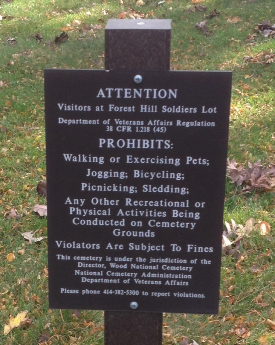
Prohibited activities with in Forest Hill. Photo by CS Thomson.
According to the zoning ordinance, Forest Hill is in the Conservancy District and its purpose is to recognize and protect the biological functions of certain natural and recreational areas. Similar to the open space special use classification, the city applies this zoning classification to every cemetery within its jurisdiction (City of Madison Municipal Code § 28.094). Since Forest Hill is a public cemetery, the city also adopts regulations that establish who is responsible for the land and outline how they should manage and maintain the space. Here, the Madison Board of Park Commissioners has the power to adopt rules that relate to the use of cemetery lots and interments and the cemetery manager implements the rules and performs daily tasks.
The code gives the commissioners and manager a lot of discretion with their power because (1) it identifies the functions that are vital to its livelihood and the components that embody its historic and sacred qualities and (2) it gives them the power to determine the best way to address the tasks and maintain the characteristics. The vital functions include lot prices, burial deeds, and the perpetual care fund, while the historic and sacred components refer to the Catlin Memorial Chapel, the Soldier’s Rest areas, and the effigy mounds.
The lot prices are an excellent example of the commissioners’ discretion over Forest Hill. Sections 8.11(3) and (7) state that they will set the lot prices and identify how the sales will support perpetual care of the cemetery, but the ordinances do not explain how the commissioners determine the price. The code makes several references to a more detailed set of rules but it does not state where or how to access them (City of Madison Municipal Code § 8.11).
Third, the Parks Division has an additional set of rules and regulations that it adopted in 2002 to manage Forest Hill, and the cemetery manager will provide them to anyone upon request. The rules are similar to the municipal code in the sense that they list the important functions and components but compared to the ordinances, they provide specific details about managing and maintaining each characteristic. In other words, the rules impose a sense of order and accountability to the unfettered power described above. Before we proceed, it is important to note that the parks commissioners and the cemetery manager are always respectful of what Forest Hill represents as a land use and to the deceased and their loved ones.
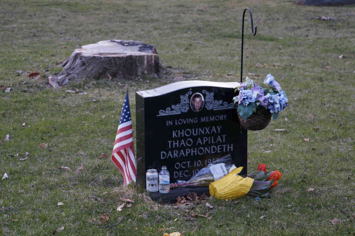
The rules fall within two categories: lot and aesthetic. The lot standards, which include land and memorials, define acceptable actions. They are similar to zoning regulations because they provide minimum size and bulk plane standards (i.e., the number of remains or memorials per grave space). In contrast, the aesthetic rules are proscriptive because they expressly prohibit plants and decorations with specific characteristics and state acceptable locations for the items. The rules provide the following requirements for plants and decorations:
- No spiny, prickly, thorny, or spreading plants;
- Only dwarf-variety shrubs;
- Only plant in front of the memorial; and
- No glass containers, unsightly tin cans, and grave blankets.
A gravesite with sprawling plants in the front and sides of the memorial. Photo by William Cronon.
A graveside with a shrub on the left hand side of the memorial. Photo by William Cronon.
In 2005, the commissioners adopted additional requirements for grave decorations and it prohibits:
- Artificial decorations, which include statutes, sculptures or other porcelain items, ceramics, metal, wood, cloth, paper, or any other materials;
- Materials around markers or on the lot that are made of plastic, wood, stone, or metal (e.g., mulch, edging, fencing, etc.);
- Shepherd hooks or similar devices that hang potted plants or other objects;
- Wind chimes, pinwheels, windsocks, or other similar items; and
- Lamps, candles, solar lights, neon signs, or illuminating devices.
A graveside with several decoration violations. Photo by William Cronon.
It is reasonable to believe that the commissioners established these rules to preserve the historic and sacred atmosphere of Forest Hill, but as you walk through the cemetery, you will see several graves that violate these rules. During an interview, the manager described an informal honor code for the proscriptive rules. Under this code, the city, lot owners, and frequent visitors respect the diverse cultures and religions of the deceased by allowing unobtrusive decorations.
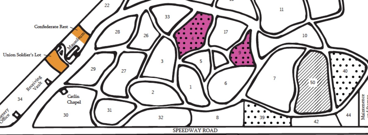
Some of the lot and aesthetic rules apply to the entire cemetery and others are only relevant in specific sections. For example, general lots must be a minimum three and one-half feet wide and nine feet long, but in sections four and nine, the required size is four square feet. Furthermore, the monuments in sections four, nine, 35, 39, 40, and 41 must comply with specific design standards. The Zoning Map illustrates the locations and types of mandated idiosyncrasies within Forest Hill.
The layout of gravesites in Forest Hill. Photo by William Cronon.
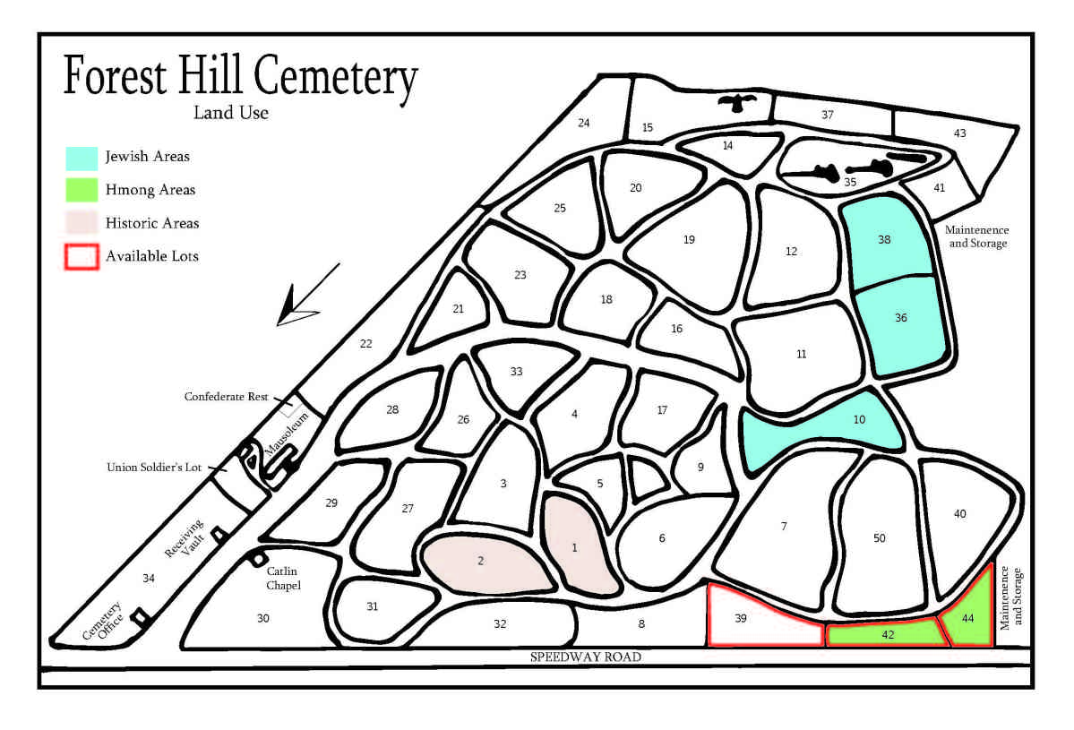
The Parks Division Rules and Regulations create specific ‘zoning districts’ and ‘overlay zones’ in areas of the cemetery. In general, municipalities divide their jurisdiction into districts to separate incompatible uses and to impose specific building and density requirements in each area and sometimes they create overlay zones to impose additional criteria that manage development in select districts (e.g., municipalities use overlays for economic development, groundwater quality, and stormwater management purposes). The following map identifies the zoning districts and overlay zones in Forest Hill.
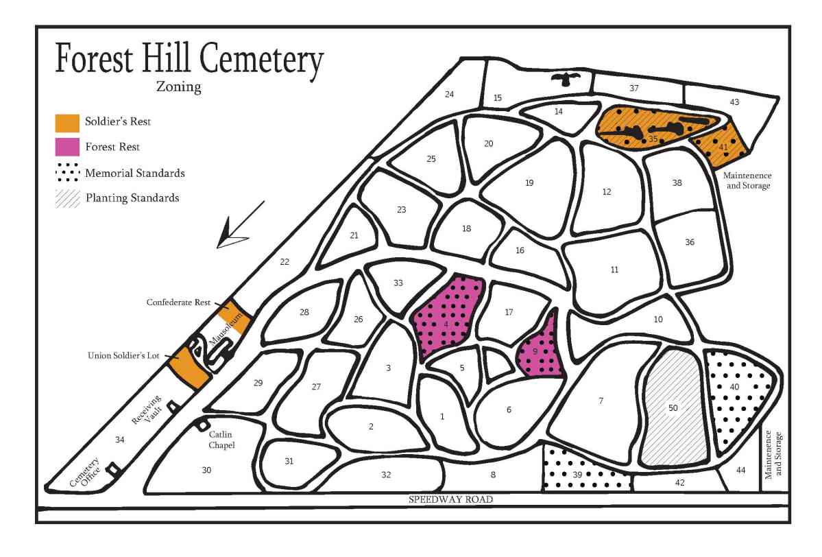
Forest Hill Zoning Map
For a PDF of this map, click here.
The zoning districts include Soldier’s Rest and Forest Rest. The commissioners designated sections 34, 35, and 41 as “Soldier’s Rest” to accommodate people that served in the military. They dedicated two portions of section 34 to commemorate soldiers that served in the Civil War, and reserved sections 35 and 41 for soldiers, sailors, marines, nurses, and officers that meet three criteria: (1) served in a war or campaign with the United States government, (2) received an honorable discharge, and (3) died a City of Madison resident. If a person meets this criteria, the city gives one lot to the military member when they die and a second lot to their spouse.
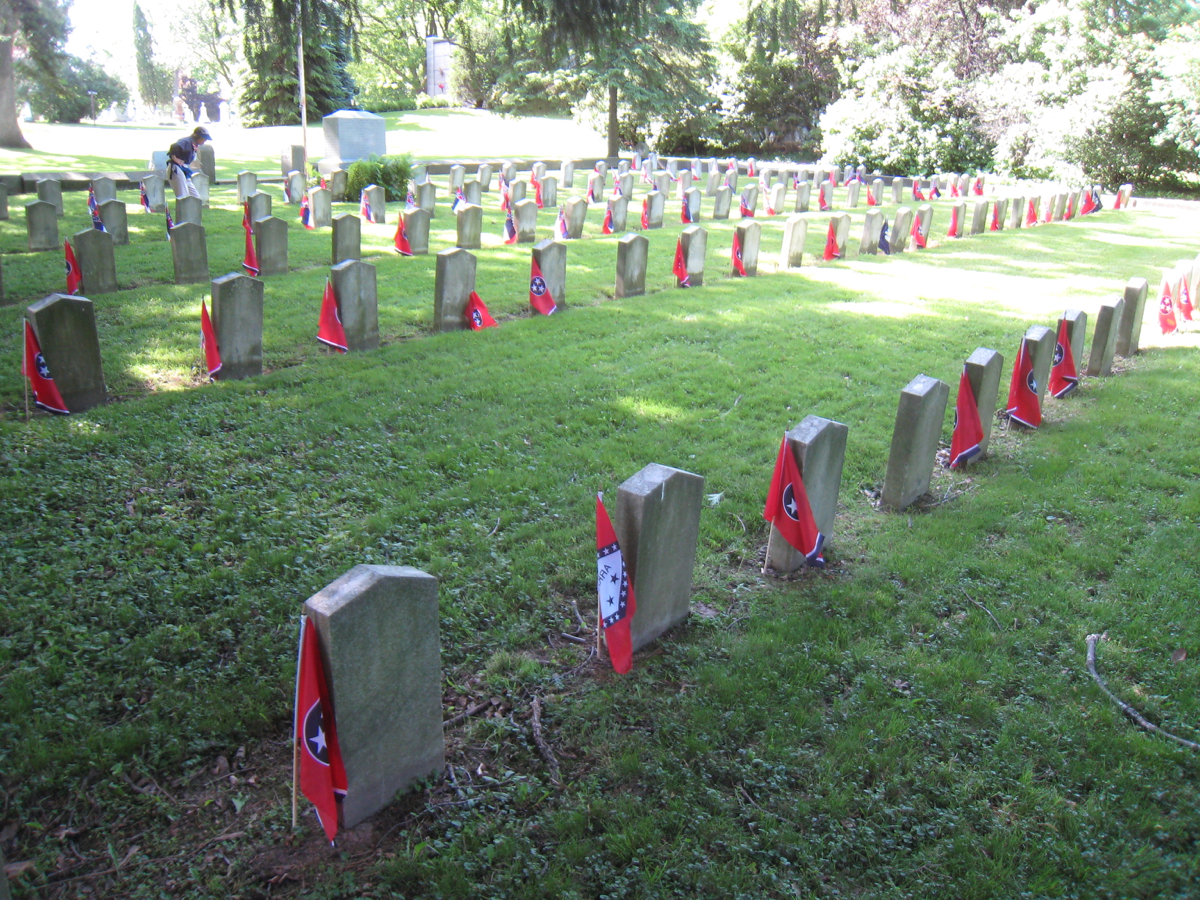
The Confederate Rest area in section 34. Photo by William Cronon.
They also classified sections four and nine as “Forest Rest” and only permit the interment of cremated remains in the district. Based on this limitation, the lots have particular size and bulk plane standards, and here the required lot size is four square feet and each lot can accommodate up to four standard size urns (i.e., 6” x 6” x 6”).
As mentioned above, the rules also identify specific planting and memorial standards for particular sections, and they apply to more than one section so they function as overlay zones within Forest Hill. The planting overlay zone includes sections 35, 41, and 50 and it expressly prohibits shrubs or trees on the lots. The memorial overlay zone includes sections four, nine, 35, 39, 40, and 41 and the standards vary within each district or section. The following table identifies the limitations:
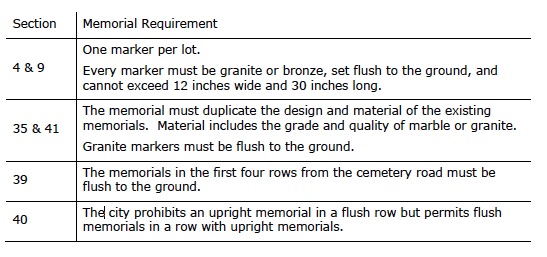
Forest Hill Memorial Overlay Zone Regulations by Section.
The rules do not always provide a rationale for the overlay zones, but given the characteristics and locations of the limitations, it is reasonable to believe that they relate to the base zoning district and the surrounding environment (i.e., Speedway Road and Glenway Golf Course). The city enforces the zoning rules to protect the welfare of the cemetery for Madison residents.
When you look at the zoning map, it is evident that the commissioners impose additional standards on a small proportion of Forest Hill, but as you walk through the cemetery, you will notice three distinct sections that are not in the previous discussion: the historic, Hmong, and Jewish areas. These areas symbolize the time and the people that initially inhabited the sections, and consequently, they identify the observed idiosyncrasies within Forest Hill.
Municipalities create land use maps to illustrate the existing characteristics of an area (e.g., the type and intensity of development or natural resources) and the categories are not always the product of the zoning code. The land use map identifies the areas with distinct characteristics and they emerged from community or individual decisions opposed to municipal regulations.
Forest Hill Land Use Map
For a PDF of this map, click here.
The historic area contains the first gravesites within Forest Hill and it includes some of the earliest residents of Madison. For example, Darwin Clark is buried in the southwest corner of section two and he was one of the original permanent settlers. He also helped build the first Capitol. Since 1857, the cemetery has sprawled in all directions from sections one and two, but physical barriers (i.e., Speedway Road, the residential neighborhood, and the golf course) have confined the cemetery to its current footprint. Unfortunately, the cemetery manager does not know the exact order in which Forest Hill grew, but as you meander throughout the sections, it is entertaining to look at the dates on the gravestones and hypothesize various development patterns.
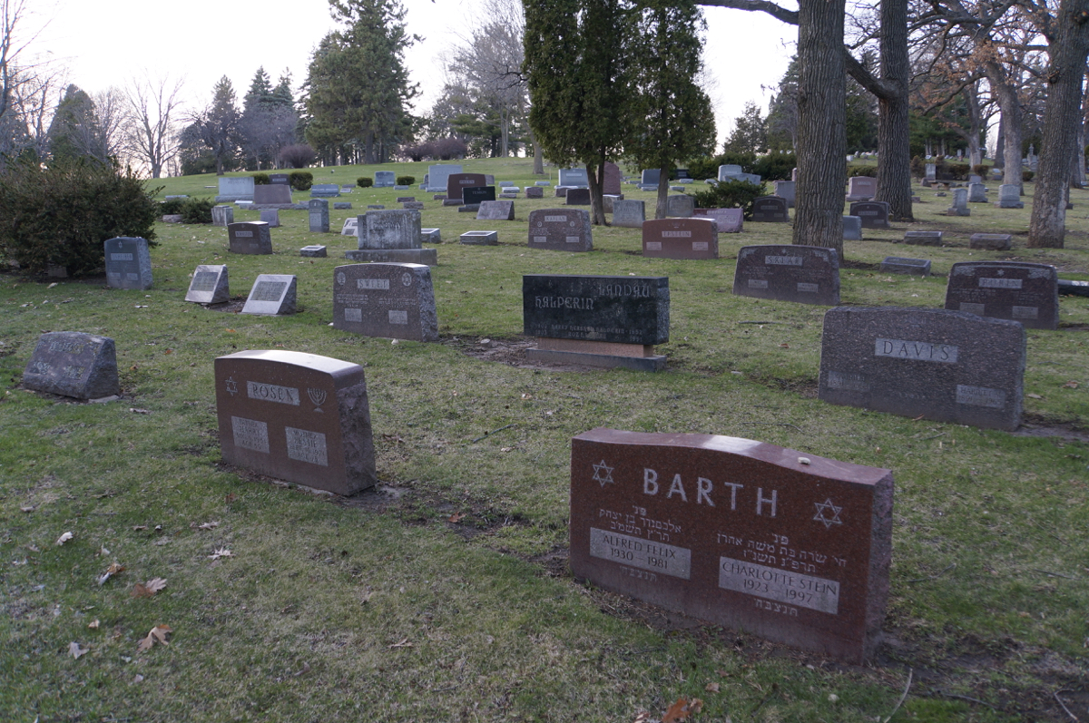
Forest Hill has two distinct Jewish areas: section ten and sections 36 and 38. Section ten includes some of the first Jewish residents of Madison, and when the city added sections 36 and 38 in the late 1910’s to early 1920’s, several Jewish families purchased all of the lots to secure space in Forest Hill for their community. According to their traditions and burial rituals, they protect each other by owning land so the sections signify the unity of the Jewish community in Madison.
Compared to the Jewish sections, the Hmong area developed in an ad hoc manner but it represents similar value for their community. Hmong people have strong ties to their family and they maintain this relationship after a loved one dies by visiting their gravesite on a regular basis. They also believe that their final resting place must have certain characteristics, which are difficult to satisfy in the United States. Forest Hill does not necessarily embody the characteristics, but the cemetery’s centralized location within Madison and their visiting rituals provide some explanation for the distinct Hmong area.
The Hmong first came to Madison in the 1990’s as refugees from the Vietnam War so their community is relatively new to Madison, and this explains why their area is in the only part of the cemetery with lots for sale.
As of Spring 2015, there are less than 1000 available lots that anyone can purchase and they are located in sections 39, 42, and 44. When you walk through the southeastern and southwestern areas of the cemetery, you will notice a large amount of open space, particularly in sections 41 and 50, and this observation alludes to three possible scenarios: First, the city has sold or reserved all of the lots but the owners are still alive. Since section 41 is part of the Soldier’s Rest zone, the city reserves all of the open lots for military members and they still own several lots. Second, the memorial is flush to the ground, which gives the illusion of availability. Or, third, the landscaping occupies several lots within the section (i.e., tree roots or shrubs make it impossible to bury a body in the space).
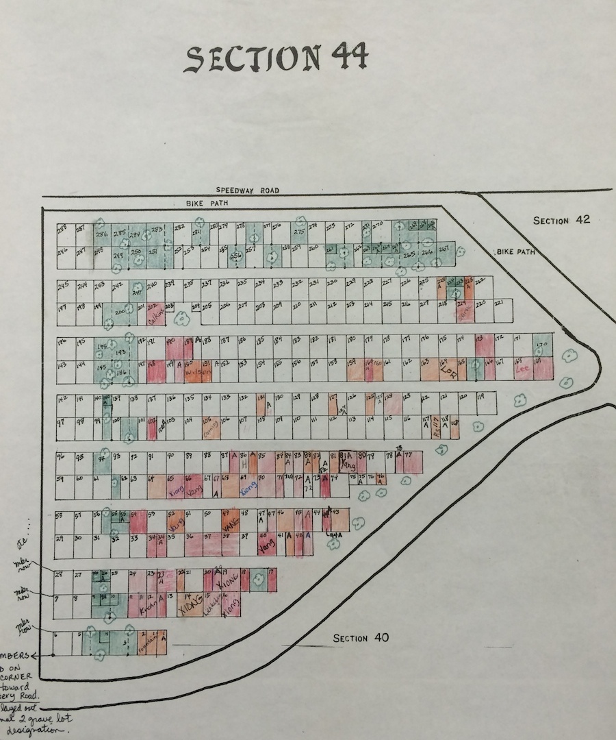
The public record for the lots within section 44. Photo by Lauren Suerth.
If you visit the Forest Hill Cemetery office during normal business hours, you can view the city’s public records for the sections and lots. The city maintains a color-coded map for each section that shows the location and size of every lot within its boundaries: orange-red indicates a purchased lot, green identifies a lot that is occupied by a landscaping feature, and white refers to an available lot.
Back to Top | Geography of Death Main Page | Overview of Death Care Industry | Dane County’s Death Investigation Unit | Muckraking and Consumer Protection
SOURCES
City of Madison, WI, City of Madison Comprehensive Plan (Madison, WI: City of Madison, March, 2012).
City of Madison, WI, City of Madison Municipal Code, 2014.
Forest Hill Cemetery Committee of Historic Madison, “Forest Hill Cemetery: A Walking Tour” (Historic Madison, Inc., 1993).
Jonathan Z. S. Pollack, April 30, 2015.
Karen Thompson, April 28, 2015.
Laura Bauer, April 14, 2015.
Parks Division Department of Public Works, “Forest Hill Cemetery: Rules and Regulations” (City of Madison, WI, 2002).
Parks Division Department of Public Works, City of Madison 2012-2017 Park and Open Space Plan Madison, WI, May 15, 2012).